
by Azadeh Rahnama and Lulu Dombois
“The gardens surround it (the city of Damascus) like the atrium surrounds the moon, they embrace it like the chalice embraces its flower. To the east, their green surroundings extend as far as the eye can see: wherever you look on the four sides, your gaze meets their ripe fruit. Those who said, ‘If paradise is on earth, then without doubt Damascus is part of it. If it is in heaven, then it competes with it and shares the glory’, spoke the truth.” (Ibn Jubayr, 1184)
Damascus, the capital of Syria, is embedded in a fertile irrigation oasis, the so-called Ghuta (Arab. for “fertile plain with trees”) and is bordered in the north by Mount Qasiyun, a spur of the Anti-Lebanon Mountains. In the south, the Ghuta is separated from the Al-Aswad and Al-Mani mountains by the 700–900-m-high volcanic mountain range from the Hauran, the granary of Syria. In the east, the plateau without a natural border runs through the Syrian desert, a desert steppe. The Barada River is the main source of water for the city and its Ghuta. Originally, the Ghuta extended in a radius of about 7–10 km around the old town of Damascus, its area stretching like a belt around the city walls. The oasis was created on the fertile soils, which were washed down by the molten rainfall from Mount Qasyun.

The importance of the Ghuta
The Ghuta of Damascus was the largest and most famous of the oases of the Orient. It was not only an agricultural area, but also had numerous other functions and had a strong historical, ecological, supplying and cultural importance for the city of Damascus. The Ghuta owed its extraordinary abundance of water to the Barada, which was divided into seven branches and carried such clean water that the inhabitants of the Barada Valley continued to fetch their drinking water directly from the river until the 1960s (Gurlt, 2009).
The soils of the Ghuta are characterised by high fertility, not least because the Barada once ended there in a lake that later dried up, but also because the organic waste of the city was collected by the farmers over the centuries and distributed on the agricultural land (Wirth, 2002). The agricultural use of the Ghuta took place in zones whose intensive use decreased in a ring-shaped pattern from the city walls to the surrounding countryside.


In the well irrigated and fertilised areas close to the city, mainly vegetables were grown, while further away from the city the Ghuta was characterised by extensive fruit tree groves. Nuts, apricots and olives were among the specialities produced by the Ghuta. The agricultural yields were so rich that the inhabitants of Damascus could be supplied, making the city self-sufficient.
The Ghuta has always been closely linked to the city and its inhabitants, both economically and in terms of supply and socio-cultural aspects. In addition to its function as an agricultural yield and ecological area, Ghuta played an important role as a scenic leisure and recreation area. Thus, after a hard day’s work in the noisy and dirty city, people had a rest in the garden zone near the city in the evening and enjoyed the fresh climate in their private garden or in one of the numerous tea and coffee houses in the shade of the fruit trees (Wirth, 2002). The Ghuta thus had a strong cultural significance, creating identity for the whole city for centuries, even into the 21st century.


The transformation of the Ghuta
In the late 19th and early 20th centuries, the oasis belt underwent significant changes due to the city’s rapid growth. With new residential areas and infrastructure outside the city walls, the city spread further and further, mostly uncontrolled, into the surrounding area, pushing back the areas of the green Ghuta. At the time Syria gained independence in 1941, the city had a population of around 296,000 – and by the ’80s the population was said to be around three million (Escher, 2000). This rapid population growth, caused by rural exodus, immigration and economic upswing, probably made orderly and targeted urban planning difficult. In the land use plan drawn up by Ecochard and Banshoya in 1957, the Ghuta was recognised as worthy of protection and preservation. Some concrete spaces outside the Ghuta were proposed for potential urban expansion. However, the implementation of this plan was slow and only partial. The large and small settlements within Ghuta continued to eat their way into the irrigation oasis and developed into small and large cities (Bianquis, 1984).


This phenomenon of the rapid and mostly uncontrolled growth of Damascus resulted in an extremely high pressure on natural resources, as shown by littering, leached soils, water shortages, lowering of the groundwater level, etc.
Damascus seized its own air to breathe with the uncontrolled development of its green belt. With the 2011 war, the Ghuta turned into a battlefield of poison gas attacks, sieges and conquests. The war expelled its inhabitants, destroyed the houses and burned the trees. Not much is likely to remain of the once paradisiacal gardens and flowering landscapes.
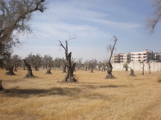
Featured image: Ghuta landscape with view over the south of Damascus to Jabal Qasyun, 2007 | Jaber al-Azmeh (CC-BY-NC-ND)
Published by Azadeh Rahnama and Lulu Dombois. Azadeh Rahnama and Lulu Dombois studied landscape architecture at TU Berlin. In 2010, they successfully handed in their diploma thesis entitled “Al-Ghouta and Damascus – a story retold” in the Department of Landscape Architecture and Open Space Planning (Prof Undine Giseke). For the research, they travelled to Syria several times between 2008 and 2010.
Thank you for all this work of memory.